Radio Canada
Interview by Emily Ridlington from CBC.
Interview by Emily Ridlington from CBC.
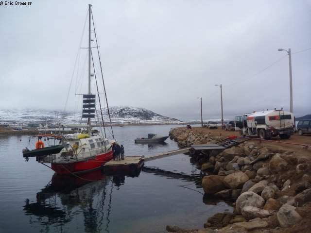
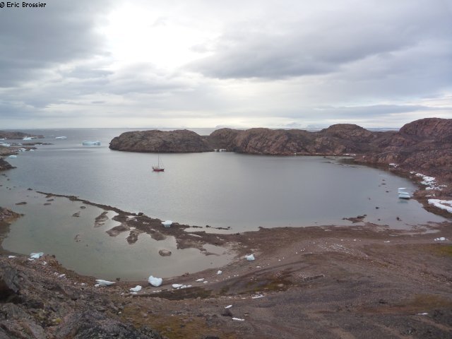
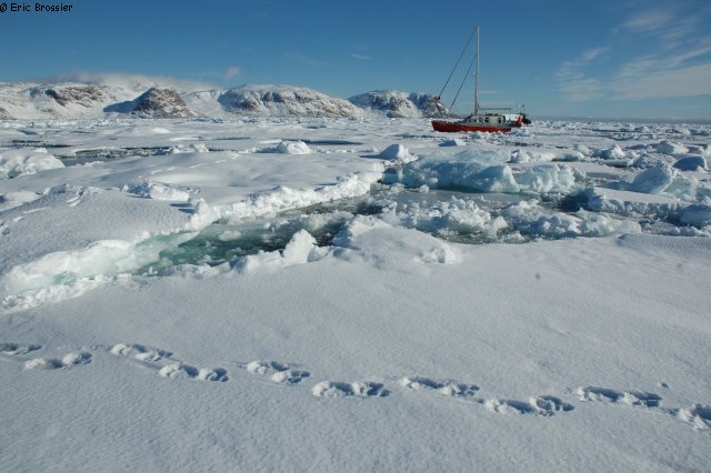
Qikiqtarjuaq, about 500 inhabitants, very welcoming. We arrived on Tuesday night, not even one week after leaving Grise Fiord. The last night of sailing was quite long: front wind (light), swell from offshore, darkness due to clouds, and the radar couldn't detect icebergs because it was snowing. At last, we found the little bay we were aiming to, 3 kilometers from the village, despite usual imprecision of the charts in these regions hardly visited.
Last Sunday in Clyde River, we had a few nice encounters, and we met Bob Shepton and his crew on board Dodo's Delight. There was about thirty boats in the North-West Passage this summer!
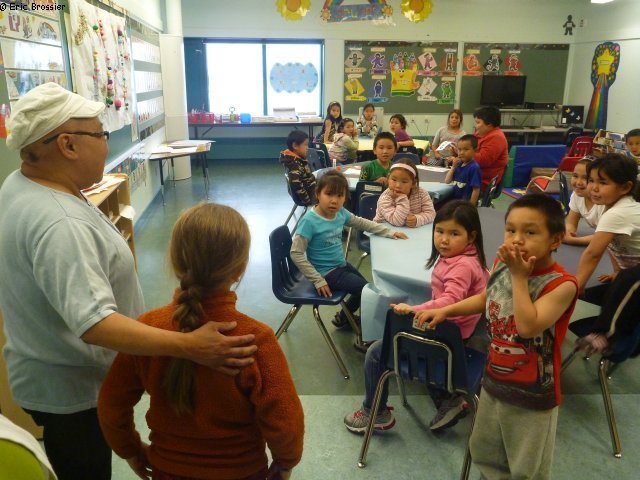
Qikiqtarjuaq is built on Broughton Island, near the huge Baffin Island. During the last very recent count, fifteen bears were seen on the little island! The population is increasing since hunting has stopped, we have been quickly warned about it. Many narwhals too, the hunting season has just finished when 26 were caught last Thursday (out of 70 per year, total quota). All boats were out of the little harbour, so it was the perfect time for Vagabond to come in to get diesel and water! Léonie is going to Inuksuit school since Wednesday, Aurore found the house for "Parents and Tots", both of them are very happy to have new friends. With many gifts from our friend nurse in Grise Fiord, who has been leaving here for five years, we are gradually meeting with people in Qik.
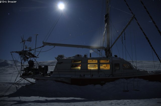
What a comfort to have a real good shelter so close to town! Before freezing, when the sea is calm, we can go to town using our dinghy in about twenty minutes, or we can move Vagabond and temporarily drop anchor in front of the little harbour.
A first press release from Emmanuel Hussenet, after our expedition in Smith Sound.
Vagabond is half way between Grise Fiord and Qikiqtarjuaq (1200km). It's the equinox, France and I have as much night than day watches. Winter is coming early this year, but luckily a nice high set up on our route. The full moon and the sun are allowing us to better see icebergs and admire the very snowy coast of Devon, Bylot and Baffin Islands. Fair or light winds are significantly reducing freezing sprays!
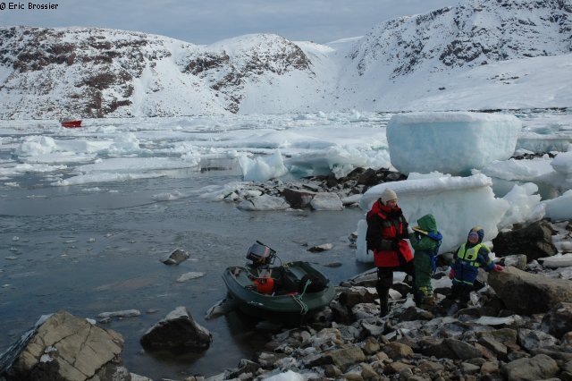
At least, France and I could go ashore in Grise Fiord on Tuesday morning, where we met with Aurore and Léonie, well surrounded. While France was making our entry to Canada official, with Ed and Patrice from the Royal Mounted Police, I was climbing the nearby mountain to pick up the third and last camera. A young dog followed me all the way, sometimes a bit scared in the snowy slopes! In the evening, when it was getting dark, it was time to set sails. Again, many friends came to the shore, this time to say goodbye to each other. A lump in our throats. Two years of sharing, hard to turn over a new leaf.
Yesterday morning, our little family crew woke up at anchor, shelterd by Cape Bathurst (Bylot Island), rested. A polar bear walked on the beach, peacefully. Not long after, Vagabond met her own track from ten years ago, while sailing around the Arctic.
Tomorrow, we will stop in Clyde River, the only village on our way.
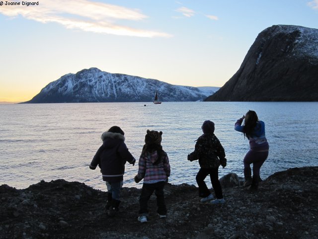
"Léonie ! Léonie ! Léonie !", were chanting her friends while we were approaching the beach by dinghy. Many of our friends from Grise Fiord were here, Saturday evening, to welcome us on our return from Greenland. A little tired after the trip from Qaanaaq, we were all the more moved. Happily we had fair winds, but heavy swell and broken down autopilot. France fall on her head, of no consequence but an unscheduled stop at Carey Islands. Magnificent archipelago, totally uninhabited, but better sheltered than expected, perfect to get some rest. As for Léonie (6) and Aurore (3), they have been in great shape all along the crossing from Greenland to Canada! And they are delighted to be in Grise Fiord since, welcomed by Joanne, the nurse.
France and I left straight away for South Cape Fiord, five hours further. Exceptional weather gave us a chance to accomplish a few missions, and to say goodbye to our unforgettable wintering location (2011-2012). After a short night at anchor, we first had to climb the nearby pyramid to recover two cameras, set up with Christian Haas in May. Little snow after all, very practicable terrain, and a beautiful view. No wind and sunshine, we stayed more than one hour at the summit. Then we couldn't leave the area without doing a CTD in the middle of the fjord, at the usual place. Also two lines of soundings, still looking for more explanations on specific exchanges happening between this fjord and the ocean. Sampling plankton in the end, and we were heading back to Grise Fiord, happy after this little week-end just two of us!
Wind and swell is keeping us on board since last night, we are looking forward to go ashore to see again our friends before sailing South.
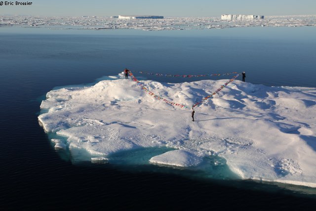
September 6. Waiting for high tide to raise the anchor, we enjoy again the sun for a picnic ashore. But it is time to sail south. Ice came close to the coast with the south-west wind. The light is beautiful. In support of its awareness message about Arctic lusts, Emmanuel with Catherine and Bénédicte are deploying 193 colourful flags on a nice ice floe. Vagabond is sailing around them to capture images of that symbolic moment. Emmanuel, committed writer, will send later his message to all countries. As expected, fog is coming and wind is picking up around one in the morning, Vagabond drops anchor near Littleton Island, in a small bay that dries up almost entirely at low tide! On land, we are still seeing a lot of remains of stone huts.
The next day the wind is still blowing hard when we seek an anchorage for exploring the island of Littleton. Having sailed all around, a part of the team manages to land in search of traces left by the explorers of the last century. Unfortunately the snow is hiding most of it, only the large cairn at the top of the island is easy to access. Again, we find a bottle and a message left by the crew of Dagmar Aaen, 4 years ago. Eric can still inspect the weather station repaired two years ago. The wind is strong, very strong at the top of the island. Vagabond is pushed by the wind, she quickly moves on to the nearest shelter, Kenrick Bay, waiting to pass the famous Cape Alexander. The wind dies down the following day, the road is radiant along the snowy coast. So quiet that the plankton net is launched, tiny and very red bodies are going crazy at the bottom of their bottle! In the night Vagabond drops anchor a few hours from Qaanaaq, one day ahead of the plane's departure of our friends.
Aurore and Eric are going ashore, splendid weather, while the rest of the team is sleeping in. But later, the ultimate picnic trip is suddenly cut short by severe storms. We rush to the beach as soon as possible. The sea, glassy before, is already rough when we are going back to Vagabond by dinghy. Very quickly, we get forty then fifty knots of wind, then sixty, even sixty five knots in gusts! The anchor doesn't hold, the sea is white, bits of icebergs are passing quickly nearby... We have to use the engines, all afternoon, to avoid drifting. Some worries, children's stories, everyone keeps busy on board, also admiring the sight outside, while tacking on the spot! The next morning the wind finally calm down, the anchor has drifted for 800 meters! Vagabond has just enough time to sail to the airport to drop off the team, without even going through the village.
Alone again, all four of us are going to visit Hans and Birthe, enjoying the nice weather, on land. By a happy coincidence we meet Marius and Naja, we were so warmly welcomed at their home in Savissivik two years ago. And we are disappointed that we cannot accept their invitation, since we're on the start, the weather window can not wait!
The Fram Bay is a protective trap, Vagabond could spend the winter there... The ice pack is drifting through Rice Strait since yesterday (September 1st) and we decide to try to follow it, heading south. Right out of the bay we are carried on a kind of conveyor belt which carries aggressive floes, thick, with little room for sailing. Not to mention the little headwind pushing Vagabond on an edge of the narrow strait. When movements are decreasing, it is because the channel is filled up, the ice is embedded in a giant puzzle. A too high floe just stamp the back of Vagabond already locked, bending the cable holding the mast under the rear platform... Fortunately, it simply deforms under pressure.
We struggle to avoid over exposing the hull, and less than one nautical mile is covered in half a day! After an hour of respite, to our surprise, the current is reversed, this time we try to go back to the north. Quickly reaching the exit of the channel, we finally discover a channel of open water along Pim Island, we are out of the trap! We are passing Clay camp, but there is too much snow to watch. In addition, a large barrier of dense pack still separates us from the open water towards Greenland. We are at the narrowest point of Smith Sound and we can see it, pink in the setting sun, 20 nautical miles away, far less snowy than Canada. Scientists, who are sending us ice charts and satellite images, are announcing winter conditions one week earlier than usual. In the North West Passage, some sailboats surrendered. Further north, Babouchka's crew has just been recovered by a Russian icebreaker. In Kane Basin, north of Smith Sound, new ice is already forming. After an unsuccessful attempt, we moor Vagabond to an ice floe, near Brevoort Island, where it is impossible to land: we were hoping to inspect, even repair the weather station, recently destroyed by a polar bear, presumably. While drifting, Eric manages to make a final measure with the CTD (finishing the Smith Sound section). At 11pm, enjoying the calm before the announced wind, Emmanuel returns to the pole, Eric at the helm, while France is back in the crow's nest to guide Vagabond through the maze of ice. At four o'clock in the morning she goes down, less ice. At 6am, in the first gusts of wind, Vagabond anchored in the good shelter of Cache Point, a beautiful small and steep bay. Only Aurore, Léonie and Eric are going ashore, always eager for discoveries: remains of Inuit settlements (rings of stones), hut remains, cairns and inscriptions left in the lichen by rare sailors and hunters.
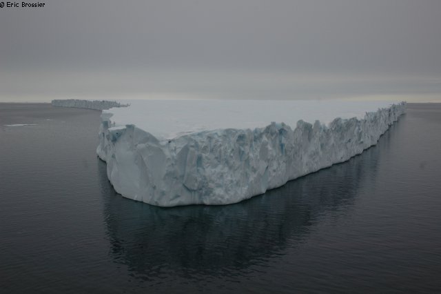
On September 5, after a good rest, we decide to go explore a little further north, Inglefield Land, definitively leaving aside the initial project of setting foot on Hans Island, too far north and submerged in ice (last ice map is impressive!). Along the way we are approaching another ice island (PII2012A1d), smaller than the first but steeper. Majestic ice cliff that Vagabond is sailing along then around, before continuing in a heavier and heavier fog. Emmanuel takes advantage of better weather for a film session, walking alone and bewildered, on an ice floe... The maps become shifted, badly drawn, completely wrong! Tonight, to enter Inuarfigssuaq Bay, 78°31'North (Marshall Bay), only the radar can help us in blowing snow and persistent fog. South wind got up again, it's not until morning that we discover our shelter, which a large portion is dry: at low tide, there is no more than a meter of water under the hull! Finally, the sun is back. It is here, at the northern most of our journey (toast!), that we lay the food and fuel depot for Alex Hibbert (Dark Ice Project). After unloading by dinghy, we need more than three hours to bury somehow under stones 8 drums and 11 bags, to protect them from curious and voracious bears.
Meanwhile, Catherine and Emmanuel are taking pictures of each of their 193 flags, in this high latitude pristine landscape. The place is beautiful ... Hills and mountains offer several point of view on the ocean, three freshwater lakes nearby, maybe well stocked with fish, an ideal place for winter! Cans of fuel indicate that the site can be used by aircraft for landing.
of Denmark)
I believe that what we observe presently is a new area but who knows about the past when we did not have satellites to assist us?
When I first observed the calving of the Petermann Glacier some times in the 90-s it was based on satellite images of the Kennedy Channel that had three floes that were different from all the other floes coming from the Lincoln Sea. It was based on SAR scenes recorded by chance by the European satellite ERS-1 some weeks after its launch in 1991. Fortunately, other observations taken two and four weeks before showed that the floes came from Petermann Glacier. Based on previous observations from aircraft I suggested that calving would take place every 9 or 10 years.
The next calving took place in 2000 so I was right, but since then climate has changed so we had the next major calving in 2008 although smaller than before and what we have seen recently. As you know we had other calvings from Petermann Glacier in 2010 and now also in 2012. And very large ones coming from further up the floating tongue of the glacier which means that the thickness and therefore the draft has increased (the main melting process of the glacier tongue takes place from the underlying water).
This means that we have more ice islands than before and due to the increased draft the probability of grounding increases. Yes, it is a special situation that we experience.
ERS-1 scenes of the Lincoln Sea showed that in 1991 there were also an ice island with origin Steensby Glacier or Ryder Glacier but I have only one observation. What we see now is that this happens again and more frequent than before.
In all you observe a unique situation with the many fragments of calvings from Greenland distributed by chance along the coast of Baffin Island sounding the (unknovn) coastal bathymetry. Not knowing the exact draft of the bergs it is of minor interest. Several of them have been grounded on the way and later left the place to ground on another ground further south.
Yes, you experience something very interesting.
Rosse Bay. We are fighting in the ice and getting to our usual positions, one in the crow's nest guiding the other one steering. But soon we must moor Vagabond to an ice floe, the largest possible, because of 15 knots of wind making dangerous our progression. So moored, Vagabond is drifting gently, a few miles south of Pim Island that we would like to explore. The next day is very quiet, beautiful weather, we walk around our ice floe, it is like a maze with many melt ponds already refrozen. Temperatures are dropping below zero. This morning a bear came close to us, seals are sighted, and even a cabin on a hill, probably built during a scientific expedition. It's only after 36 hours of drifting that Vagabond can finally make her way to Pim Island. Behind us, heavy pack ice. In front of us, Rice Strait between Pim and Ellesmere Islands. We pass Fram Haven, a small bay where Bart Veldink (Dutch sailor) spent last winter alone aboard his sailboat "Tranquilo"... A huge ice floe is blocking the exit of the Strait. Vagabond is moored to the ice again, and thanks to it we can reach Pim Island, already very snowy (end of August!). Historical site, everyone is thinking of the suffering members of the Greely Expedition, 130 years ago.
Looking for a way out, we return to Rosse Bay, no luck, too much ice, so back to the ice floe that is still closing the exit of Rice Strait. Summer is cold this year in the Arctic, conditions are stopping many sailors. Near the North Pole Babushka just trigger her emergency beacon. A few days earlier, Tooluka renounced the Northwest Passage...
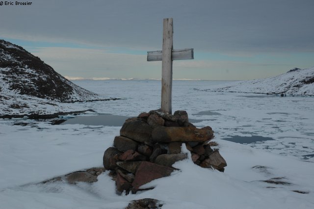
Finally, we find refuge in Fram Haven. Beautiful. Sverdrup and his crew had wintered there in 1898-99 aboard the Fram. A cross was erected on a rock at the death of Svandsen, the expedition's doctor. We also find the remains of a cabin of the Royal Canadian Mounted Police.
Hesitation on the best strategy: the ice is drifting gently into the strait, the sea surface is freezing, the forecast is easterly winds... We had not planned to spend the winter here!
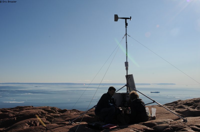
A thin layer of snow is now covering the landscape. While Vagabond is passing near Littleton Island, we can see the weather station, repaired two years ago (see weather data live). We will try to visit the island on our way back. For now, it is a special quest we are starting in Smith Sound.
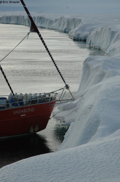
Following the instructions of enthusiastic scientists, carefully observing polar ice drifting south through Nares Strait (between Greenland and Canada), we are heading for the last known position of PII-2012-A-1. On the way, while crossing Smith Sound, we are doing three CTD casts. Drifting at more than one kilometre per hour, bigger than the nearby Pim Island, PII-2012-A-1 is a huge piece of ice (95 sq km) from Petermann glacier (North-West Greenland), it broke in 2012 and it is drifting with winds and currents when the sea is not frozen. We have to sail through heavier pack ice when, at least, we find the endless undulating area, three to ten meters high above the sea level, very different from usual pack ice and icebergs. On the leeward side, there is open water, a swimming polar bear is welcoming us, we have time to watch him. A little later, Vagabond is moored to the ice island, and another bear is coming to check our rope! We can watch him from below for a pretty long time. The bear is then lying down at a few hundreds meters, but he doesn't seem interested with the crew coming onto the drifting glacier several times, curious about this unusual field. The icemeter (EM31) is used for one of our trips, will it be able to tell us more about the thickness of the ice? With the stem against the ice wall, we have a very nice night, drifting south. We travel more than 20 kilometres! A camera is then installed on top of the mast to take a picture every ten seconds, while we are sailing around the ice island at a constant distance of one hundred meters. Every details of its sides, which we enjoy discovering, are immortalized. At the northern tip, we face heavy pack ice and we have to turn towards Canada.